This week the department’s National Collaborative Research Infrastructure Strategy (NCRIS) team is celebrating Earth Science Week, which runs from 8-14 October 2023.
Earth science research is critical to understanding the future and the past of our planet. It covers everything from geology, to planetology, mineralogy, and many other disciplines.
“Earth science – including the fundamental and applied geosciences we’re celebrating this week – underpins how we understand our continent, and how we respond to national challenges in critical minerals, energy and water security, and natural hazards like earthquakes, floods, and coastal erosion,” the department’s Acting Assistant Secretary for Research Policy and Programs, Tony Rothnie said.
“We’re proud to be enabling excellent Australian earth science research through the NCRIS program.”
NCRIS supports the infrastructure that enables this critical research and during Earth Science Week we’re highlighting five impactful projects.
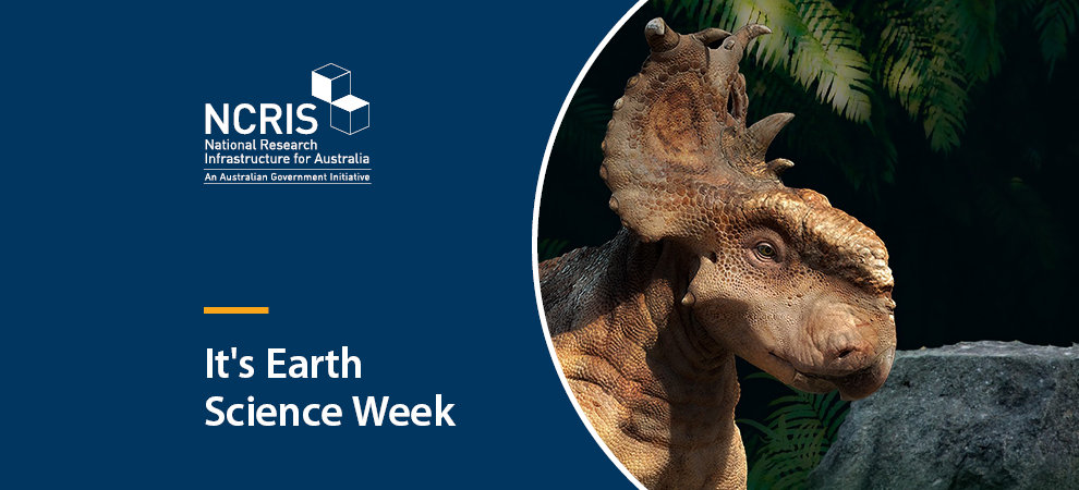
Unlocking dinosaur mysteries
No-one really outgrows their dinosaur phase, and we all delight in learning more about these creatures. The triceratops Horridus found preserved deep in sandstone, and the most complete dinosaur fossil in any Australasian Museum, has been scanned by Monash Biomedical Imaging’s large bore Siemens CT scanner, which is part of NCRIS’s National Imaging Facility.
The scans provide the important data needed to understand what sorts of sounds triceratops could hear, and the importance of vision, smell, and hearing in the daily lives of these long-extinct beasts.
Uncovering a previously unknown fault line
Australia isn’t generally known for experiencing earthquakes as it doesn’t sit close to a tectonic plate edge where seismic events are more likely to occur. But in 2021 Victoria rocked through its largest earthquake at 5.9 on the Richter scale.
According to the Australian National University (ANU), this earthquake was caused by an unknown or ‘blind’ fault that likely lies deep within the Earth’s crust.
The discovery of this new fault informs seismic hazard assessments in Victoria, which are important tools for planning and emergency response. The data behind this discovery was gathered from equipment installed in schools, as part of the Australian Seismometers in Schools (AuSIS) program run by the AuScope NCRIS facility.
Communicating complicated research across the globe
It can be difficult to communicate complicated research to both scientific and general audiences. NCRIS’s National Computational Infrastructure (NCI) facility has played a role in assisting scientists to communicate their research breakthroughs using their expert visualisation team known as ‘VizLab’.
The ‘VizLab’ helped run some of the simulations which discovered the Earth’s innermost inner core and were central to turning them into shareable imagery. The discovery was covered globally in newspapers such as The New York Times and The Guardian.
Understanding hillslope erosion trends
We don’t like to make mountains out of molehills – but hill erosion is really important. It affects everything from water quality to how fast and far bushfires spread.
Researchers using NCRIS’s Terrestrial Ecosystem Research Network have assessed the state and trends of hillslope erosion across NSW.
The NSW Rural Fire Services, the NSW Department of Primary Industry, the NSW Environment Protection Agency, and WaterNSW are using this research to make us all safer and healthier.
The future of clean energy technologies located in Western Australia
A new mineral deposit – called the Julimar Deposit – has been uncovered in Wadjuk Country around 75 kilometres northeast of Perth in Western Australia. This mineral deposit discovery is important for all Australians as it contains some of the critical raw materials that make up a range of clean energy technologies.
Chalice Mining, who discovered the deposit, decided to prospect the area because a Geoscience Australia report and mapping tool, both of which relied on the AuScope NCRIS facility, showed signs of valuable minerals around Julimar.
The Geoscience Australia team relied on the AuScope enabled Australian Seismological Reference Earth Model.
To find out more about NCRIS, visit www.education.gov.au/ncris.